Warning: Undefined array key "image-size-770" in /data/www/upgrade/australianaviation.com.au/httpdocs/wp-content/themes/australianaviation/functions.php on line 1310
Warning: Trying to access array offset on null in /data/www/upgrade/australianaviation.com.au/httpdocs/wp-content/themes/australianaviation/functions.php on line 1310
Airbus, easyJet and Norwegian sensing specialist Nicarnica Aviation have successfully created first ever significant artificial ash cloud to test new technology that detects and estimate concentrations of volcanic ash in the atmosphere.
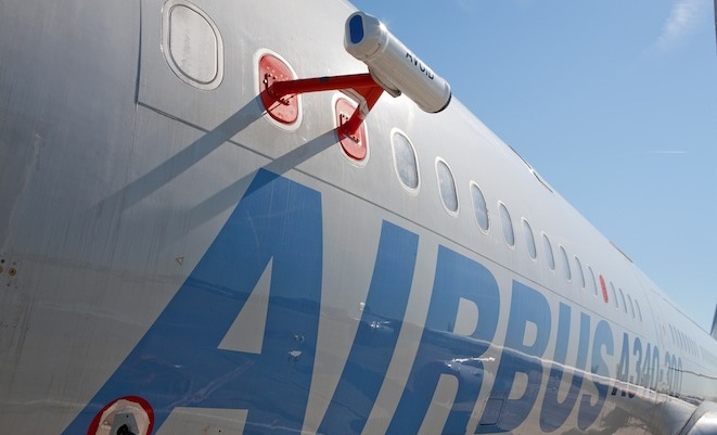
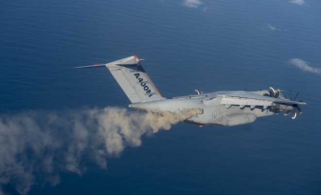
An A400M airlifter dispersed one tonne of Icelandic ash into the atmosphere at between 9,000ft and 11,000ft creating conditions consistent with the 2010 eruption volcanic eruptions in Iceland. A second Airbus test aircraft, an A340-300 with the AVOID technology fitted, flew towards the ash cloud identifying and measuring it from around 60km away.
This content is available exclusively to Australian Aviation members.
A monthly membership is only $5.99 or save with our annual plans.
- Australian Aviation quarterly print & digital magazines
- Access to In Focus reports every month on our website
- Unlimited access to all Australian Aviation digital content
- Access to the Australian Aviation app
- Australian Aviation quarterly print & digital magazines
- Access to In Focus reports every month on our website
- Access to our Behind the Lens photo galleries and other exclusive content
- Daily news updates via our email bulletin
The ash cloud produced during the test was between 600ft and 800ft deep measuring 2.8km in diameter. To be begin with the ash cloud was visible to the naked eye but dissipated quickly becoming difficult to identify.
The AVOID volcanic sensor detected the ash cloud and measured its density, which ranged from 0.1 to 1 g m-2 – or concentrations of 100 to 1000 µg m-3. This is within the range of concentrations measured during the Eyjafjallajokul eruption in April and May 2010 that grounded hundreds of thousands of flights in Europe and the North America.
The test has received worldwide attention, with the potential to more accurately detect ash clouds from on-board aircraft offering the opportunity for flights to be operated with greater safety during volcanic eruptions.
The AVOID system can be likened to a weather radar for ash. The system uses infrared technology fitted to aircraft to supply images to pilots and an airline’s operations control centre. The images will enable pilots to see an ash cloud, up to 100km ahead of the aircraft and at altitudes between 5,000ft and 50,000ft, thus allowing them to make small adjustments to the plane’s flight path to avoid any ash cloud. The concept is very similar to weather radars which are standard on commercial airliners today.
On the ground, information from aircraft with AVOID technology would be used to build an accurate image of the volcanic ash cloud using real time data. This could open up large areas of airspace that would otherwise be closed during a volcanic eruption, which would benefit passengers by minimising disruption.
Ian Davies, easyJet’s engineering director, explained: “The threat from Icelandic volcanoes continues and so we are delighted with the outcome of this unique and innovative experiment. Finding a solution is as crucial now as ever to ensure we never again see the scenes of spring 2010 when all flying ceased across Europe for several days.

“This is a key step in the final journey of testing the technology and moving towards commercial certification. easyJet will now work towards a non-integrated stand-alone system which we aim to fit onto a number of our current fleet of aircraft by the end of 2014.”